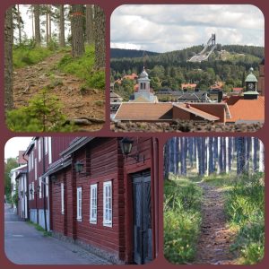
The two venues, Mora by, Säter and Lugnet, Falun offer different terrains. The terrain at Mora by is sandy with pine trees, many tracks, heights and depressions. At Lugnet the terrain is hilly with mainly pine trees, many tracks, also used for skiing in the wintertime. On the slower paths it is often rocks and roots.
Two competitions will be held at Mora by; Middle Distance and Relay

Middle Distance
Mapper: Oskar Sandberg
Scale: 1:10 000 and 1:7 500
Contour interval: 5m
Course setter: Oskar Sandberg & Kjell Klaar
Terrain description: The area consists of a pine forest with big depressions. The terrain is generally moderately hilly with some steeper slopes.The area contains a dense network
of mostly good rideable paths and forest roads. Some paths may be slow due to the sandy surface, partly old sandpit area. Good visibility.
Relay
Mapper: Oskar Sandberg
Scale: 1:10 000
Contour interval: 5m
Course setter: Oskar Sandberg & Kjell Klaar
Terrain description: A rather flat area with some moderately hilly slopes and valleys. Pine forest with a dense network of good rideable paths, tracks and forest roads. Some areas
with a very dense path network occur. Mainly good visibility, but some parts with younger forest where the visibility is lower.
And Long Distance, Sprint and Mass Start will be held at Lugnet.

Long Distance
Mapper: Steven Hale
Scale: 1:15000
Contour interval: 5m
Course setter: Stefan Johansson
Terrain description: Moderate to very hilly mainly pine forest with an extensive network of paths, tracks and fore
st roads. Some areas with a very dense path network occur. Paths and
tracks are of a wide variety of speeds. On the slower paths it is often rocks and roots which reduce the speed.
Sprint
Mapper: Steven Hale
Scale: 1:5 000
Contour interval: 5m
Course setter: Christer Morell, Stefan Johansson
Terrain description: A rather flat area with urban, forest and parkland terrain. Generally fast cycling but some short sections of technical cycling can occur.
Mass Start
Mapper: Steven Hale
Scale: 1:10 000 and 1:5 000
Contour interval: 5m
Course setter: Christer Morell
Terrain description: Moderate to very hilly mainly pine forest with an extensive network of paths, tracks and forest roads. Some areas with a very dense path network occur. Paths and
tracks are of a wide variety of speeds.
There are several opportunities for training before the event. For everyone interested in training with a map before the event, we offer the opportunity to train in three different areas around Falun and Borlänge.
• Stångtjärn, Falun
• Källviken, Falun
• Bäsna, Borlänge
More information is found in Bulletin 3
/Malin Fuhr, Responsible for media WMTBOC2022
@svenskorientering #MTBO #WMTBOC2022 @falukommun @säterskommun