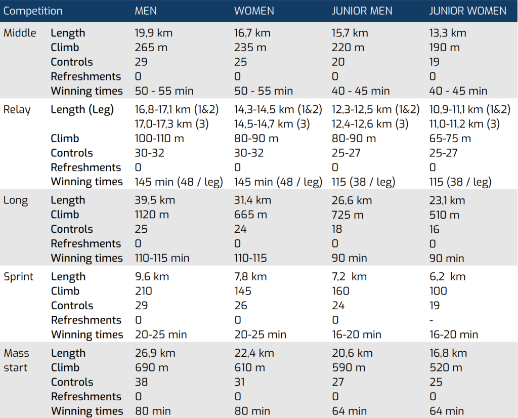
Length and climb are calculated using the shortest sensible route
Map Details/ Map Samples and Terrain Descriptions
All maps will be drawn according to the International Specifi cation for Mountain Bike Orienteering Maps ISMTBOM 2022.
Middel
Mapper: Oskar Sandberg
Scale: 1:10 000 and 1:7 500
Contour interval: 5m
Course setter: Oskar Sandberg & Kjell Klaar
Terrain description: The area consists of a pine forest with big depressions. The terrain is generally moderately hilly with some steeper slopes. The area contains a dense network of mostly good rideable paths and forest roads. Some paths may be slow due to the sandy surface, partly old sandpit area. Good visibility.
Relay
Mapper: Oskar Sandberg
Scale: 1:10 000
Contour interval: 5m
Course setter: Oskar Sandberg & Kjell Klaar
Terrain description: A rather flat area with some moderately hilly slopes and valleys. Pine forest with a dense network of good rideable paths, tracks and forest roads. Some areas with a very dense path network occur. Mainly good visibility, but some parts with younger forest where the visibility is lower.
Long
Mapper: Steven Hale
Scale: 1:15000
Contour interval: 5m
Course setter: Stefan Johansson
Terrain description: Moderate to very hilly mainly pine forest with an extensive network of paths, tracks and forest roads. Some areas with a very dense path network occur. Paths and tracks are of a wide variety of speeds. On the slower paths it is often rocks and roots which reduce the speed.
Sprint
Sprint
Mapper: Steven Hale
Scale: 1:5 000
Contour interval: 5m
Course setter: Christer Morell, Stefan Johansson
Terrain description: A rather flat area with urban, forest and parkland terrain. Generally fast cycling but some short sec tions of technical cycling can occur.
Mass Start
Mapper: Steven Hale
Scale: 1:10 000 and 1:5 000
Contour interval: 5m
Course setter: Christer Morell
Terrain description: Moderate to very hilly mainly pine forest with an extensive network of paths, tracks and forest roads. Some areas with a very dense path network occur. Paths and tracks are of a wide variety of speeds.